|
Boston Streets: Using
Cowpaths
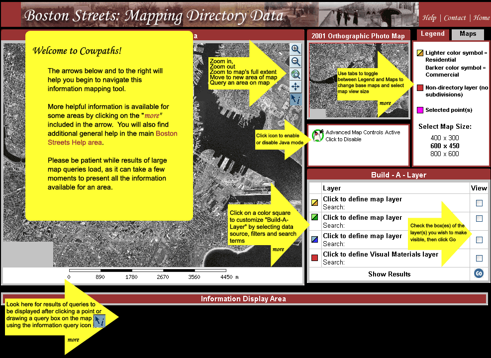
Overview of Cowpaths' Tools and Functionality:
| Build-A-Layer |
| 
|
Build-A-Layer allows
the user to define criteria for up to three information layers
and one visual material layer. You can choose to display information
from 11 city directories, filtered by residential or commercial
address and further refined through your own searches in 5
categories. Visual materials can be filtered and displayed
according to two criteria.
The Build-A-Layer and Visual Materials
toolkits provide the main access point to customizing the
information displayed in the Information Mapping Area.
|
Build-A-Layer
Toolkit
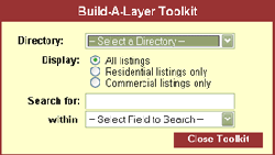 |
The Build-a-Layer Toolkit
allows you to set 4 criteria for searching and displaying
directory information
- Directory:
- Use this drop-down menu to choose directory information
to
- Display:
- Pick a raido button to display all listings, or either
residential or commerical listings only
- Search for:
- Fill in the box with a term of your choice. NOTE: Searching
is case sensitive AND punctuation
sensitive and currently allows for exact match
only
- within:
- Sets your search term into a metadata field
When you are finished click on "Close Toolkit"
and your criteria will be reflected in the Build-A-Layer area
and ready to be mapped. |
| Visual Materials Toolkit
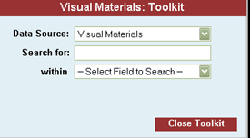 |
The Visual Materials Toolkit
allows you to set 2 criteria for searching and displaying
visual image information
- Data Source:
- Visual Materials is the only data source
- Search for:
- Fill in the box with a term of your choice. NOTE: Searching
is case sensitive AND punctuation
sensitive and currently allows for exact match
only
- within:
- Sets your search term into a metadata field (Title, Location,
Creator, Street Name, or Date)
When you are finished click on "Close Toolkit"
and your criteria will be reflected in the Build-A-Layer area
and is ready to be mapped. |
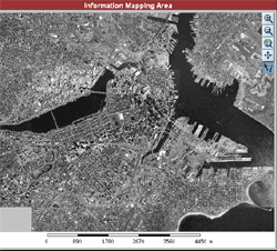
| Information
Mapping Area |
| 
|
Includes the map display area,
the scale measuer, and the java tools (when enabled). Changes
to the base map or the Build-A-Layer functions are reflected
here when the "Go" button is clicked. |
| Information
Display Area |
| 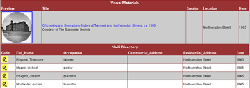
|
Information about plotted points
queried on the map is displayed here. Results from each layer
are listed separately. |
| Legend/Maps |
| 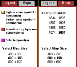
|
Legend/Maps provides a guide to the symbols
used in the Information Mapping Area, a listing of historical
base maps available for viewing in the Information Mapping
Area and Viewable Map Size choices. The Legend and Maps tabs
both offer three choices of map display sizes. Click on the
dimensions listed to change the map display size. Change the
base map by clicking on one of the listed dates.
Lighter and Darker shades of the same color (excepting yellow,
which contrasts with orange) are use to differentiate between
commercial and residential address points from selected directory
data sources. Colors and symbols are predefined by their position
in the
Accessible by clicking on corresponding tabs in upper right
corner of Cowpaths, Maps is the default tab displayed. |
Sample queries with visulaizations are
provided below the overview as a means of "touring" Cowpaths
and its functionality.
Sample
Query 1:
Search the 1845 Boston city directory for Commercial Addresses on
Washington Street and display results on an 1844 base map.
|
This query requires
three steps - querying and displaying data from the city directory,
changing the base map, and query selected points on the map.
Steps are listed below. Steps 1 and 2 are interchangeable.
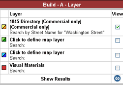
Step 1: Quering the 1845 Directory for Washington
Street and plotting results:
- Click on square icon to left of
first "Click to define Map Layer" in the Build-A-Layer
Area
- Select 1845 Directory from Drop
down Menu in the Build-A-layer control panel
- Click circle next to Commercial
Addresses
- Select Street Name as filter by
category
- Enter "Washington Street"
(without quotation marks) in Search field
- Click Apply changes to see terms
and constraints applied to Build-A-Layer Area
- Check the View box adjacent to the
1845 listing in Build-A-Layer Area
- Click Go
Step 2: Changing from the modern
base map to the 1844 base map:
- Click on the Maps tab in the Legend/Maps
area of Cowpaths
- Click on 1844 in the list of available
base maps
- It may be necessary to zoom in on
the map to the area surrounding the plotted points, see
Zoom in for help with the zoom tool
Step 3: Querying the plotted
points on the map for detailed results:
- Click the Query tool if it is not
already selected (button will change to darker blue)
- Position query tool pointer over
area to be reviewed
- Click directly on a point or click
and drag the querry tool pointer over a larger group of
points
- Detailed results will be listed
below map and the queried points will change color on the
map
|
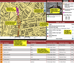
Click here
to view a screenshot of Sample Query 1.
|
|
|